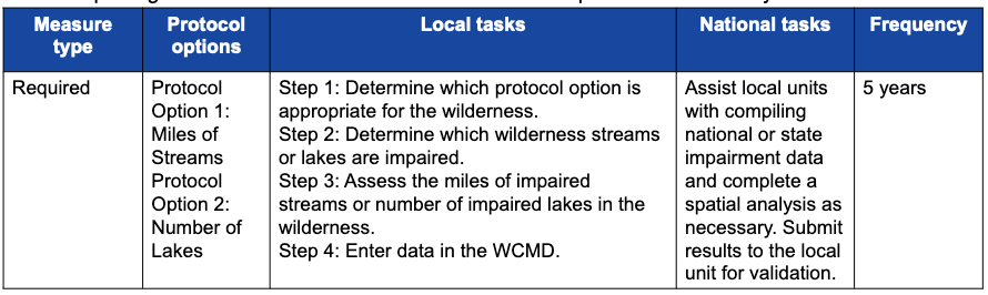
File:Table 2.3.17—Summary of measure type, protocol options, local tasks, national tasks, and frequency of data reporting for measure "Extent of Waterbodies with Impaired Water Quality.".png
Jump to navigation
Jump to search

Size of this preview: 800 × 239 pixels. Other resolution: 890 × 266 pixels.
Original file (890 × 266 pixels, file size: 67 KB, MIME type: image/png)
Table 2.3.17—Summary of measure type, protocol options, local tasks, national tasks, and frequency of data reporting for measure "Extent of Waterbodies with Impaired Water Quality."
File history
Click on a date/time to view the file as it appeared at that time.
| Date/Time | Thumbnail | Dimensions | User | Comment | |
|---|---|---|---|---|---|
| current | 21:47, 2 March 2023 | 890 × 266 (67 KB) | Admin (talk | contribs) |
You cannot overwrite this file.