Other Features of Value Quality Indicators
Monitoring the Other Features of Value Quality assesses how the condition of specific, tangible features that are integral to wilderness character change over time; it does not evaluate the other values (e.g., educational, scientific or inspirational values) derived from these features. Key indicators and measures monitor cultural features and other integral features of value. These indicators and measures are only included as part of WCM where ecological, geological, or other features of scientific, educational, scenic, or historical value exist and are integral to the meaning and value of a wilderness. This section first provides guidance on determining which features may be integral to wilderness character (section 6.1) and then describes detailed protocols for monitoring the following indicators and measures:
- 6.2 Indicator: Deterioration or Loss of Integral Cultural Features
- 6.2.1 Measure: Condition Index for Integral Cultural Features
- 6.3 Indicator: Deterioration or Loss of Other Integral Site-Specific Features of Value
- 6.3.1 Measure: Condition Index for Other Features
6.1 What Features are Integral to Wilderness Character?
A feature that is integral to wilderness character is one that makes the area's meaning and significance as wilderness clearer and more distinct. What is considered integral is anticipated to be a subset of the full suite of important site-specific geological, historical, cultural, and other features within a wilderness. Line officers will make the decision on whether or not a feature is integral to wilderness character with input from, and discussion between, wilderness managers and resource specialists, particularly regarding cultural resources. The following questions can help local unit staff and line officers determine whether a site-specific feature should be considered integral to wilderness character:
- Is the feature specifically identified in the enabling legislation for the wilderness? Features identified in the enabling legislation for a particular wilderness should be strongly considered as integral to wilderness character. Features not listed in the enabling legislation may still be considered, but the determination of whether or not to include them will require considerably more discussion and scrutiny.
- Does the feature define how people think about the wilderness or how they value the wilderness? Is the name of the wilderness associated with the feature? The focus here is on selecting those features that play a central role in defining the meaning and significance of a wilderness, rather than features that relate to broader, non-wilderness themes. In particular, if a wilderness is named after an iconic natural or cultural feature, the feature may define the area's meaning and significance as wilderness. For example, a wilderness may be integrally associated with a plant, fish, or animal such as Big Gum Swamp Wilderness, Golden Trout Wilderness, or Great Bear Wilderness. Similarly, a wilderness may be integrally associated with a physical, geological, or paleontological feature such as Glacier View Wilderness, Shining Rock Wilderness, or Fossil Ridge Wilderness.
- Is the feature nationally recognized or considered a priority heritage asset (i.e., identified as significant in an agency plan)? Features recognized by some type of national designation, such as a site listed on the National Historic Register, National Geological Site, or National Natural Landmark, should be strongly considered as integral to wilderness character. Historical and prehistoric features identified as priority assets should also be considered, particularly if the feature has a national designation. However, if a feature is primarily identified as a priority asset because of prior management investment, it may not be considered integral to wilderness character, but still could be monitored as part of the Heritage monitoring program (e.g., monitoring Priority Heritage Assets on a 5-year cycle).
- Was the feature selected as an element for Wilderness Stewardship Performance? Each local unit selected 10 elements to assess WSP as part of the Forest Service performance accountability system. Cultural resources were one of the 19 possible elements that could be selected. If this element was selected as a key aspect of stewardship performance, wilderness and cultural resource staff should discuss whether some cultural resource features should also be considered integral to wilderness character.
These questions inform whether a feature helps define the area's significance and distinguish its meaning as wilderness. Local units should consider a feature's past, present, and potential future educational, scientific, or scenic values when deciding whether to include it in WCM, even though these values will not be monitored directly. Additionally, for prehistoric or historical features, the physical evidence should convey a story about the distinctive interwoven human relationship with the land that helps enrich the meaning of the area as wilderness. Important features that are not considered integral to wilderness character may still be part of a larger wilderness monitoring program or monitored under other resource programs. For example, cultural resource staff may track the condition of historical cabins even if these features are not included as part of the Other Features of Value Quality of wilderness character. Obviously, before any discussion of potential cultural or other features of value can occur, staff must have reasonable knowledge about what features exist in a wilderness (i.e., some inventory of cultural and integral other resources has occurred). If an inventory has not been done and there is no reasonable expectation that reliable data can be obtained and monitored, then the Other Features of Value Quality should not be included as part of WCM. If only partial inventory has been done, adding additional features in future years will change the baseline number of features, thus necessitating a recalculation of previous year index values.
When considering non-cultural features that contribute unique ecological, scientific, educational, or scenic value to an area's wilderness character, it may be more appropriate to monitor such features in one of the other four qualities. For example, while an iconic mountain peak may have scenic or other values integral to wilderness character, it may be appropriately monitored by measures tracking viewshed degradation from pollutants or developments, such as Amount of Haze in the Natural Quality or a measure of visual impacts in the Solitude or Primitive and Unconfined Recreation Quality. However, there are situations where iconic natural or physical features should be monitored under the Other Features of Value Quality, such as when the complexity of ecological systems makes it difficult to determine a trend in the measure under the Natural Quality (see section 3.6 in part 2). For example, an iconic mountain bald in a southern Appalachian Mountain wilderness may make the wilderness distinctive and provide rare habitat for indigenous species; however, if it is unknown whether ecological changes to the bald are due to natural or human-caused forces, such a feature would be more appropriately monitored in the Other Features of Value Quality. This is appropriate because trends in measures under the Other Features of Value Quality may be defined by human values (e.g., the continued existence of the unique feature), whereas trends in measures under the Natural Quality are defined by threats to ecological systems from modern civilization.
This quality focuses on identifying discreet, site-specific features that are integral to wilderness character, however, there may be situations where no single feature captures what gives a wilderness meaning and significance. Instead, the local unit may believe it is the cumulative total of numerous sites that define the meaning and significance of a wilderness. An example might be numerous prehistoric pit houses, none of which are significant on their own. Likewise, it may be the accumulation of numerous fossil sites that are significant, not a specific site in particular. In these situations, the monitoring effort will clearly require more effort compared with monitoring only a few sites.
6.2 Indicator: Deterioration or Loss of Integral Cultural Features
This indicator focuses on the condition of specific, tangible cultural features that are integral to wilderness character. There is one measure for this indicator that is required if relevant to the individual wilderness.
6.2.1 Measure: Condition Index for Integral Cultural Features
This measure is an index that aggregates the condition rating for each cultural feature (or collection of similar cultural features) determined to be integral to wilderness character. Local data are compiled and periodically entered in NRM-Heritage, NRM-Buildings, local archives, or other state or regional database. NRM-WCM calculates the measure value. Table 2.6.1 describes key features for this measure.
Protocol
Step 1: Determine which cultural features are integral to wilderness character and feasible to monitor. For this measure, cultural is defined broadly to include both prehistoric and historical features. Only those cultural features determined to be integral to wilderness character should be included in this monitoring (i.e., those features that define the meaning and significance of the area). Detailed information about how to determine what features are integral to wilderness character can be found in section 6.1 in part 2. Wilderness staff will need to work closely with heritage and facilities staff to identify what cultural features exist inside wilderness, determine if those features are integral to wilderness character, and assess monitoring feasibility. Note that when consulting with heritage staff, the word feature as used in this measure is functionally equivalent to the word sites used in the FS Heritage Program and in the NRM-Heritage application.
Local units currently monitor select cultural sites as part of the existing heritage program (e.g., Priority Heritage Assets), and may also monitor some structural cultural features through the facilities program (e.g., historical buildings). Additional information on cultural resources inside wilderness may be found in NRM-Heritage, NRM-Buildings, State Historic Preservation databases, Tribal Historic Preservation Offices, local archives, and local knowledge from tribal and community members not recorded elsewhere. Where there is little or no information about cultural resources within a wilderness, some inventory may be necessary before local managers determine whether any features are integral to wilderness character.
In deciding which cultural features to include in this measure, it is essential to consider monitoring feasibility. While some cultural features are regularly assessed by the heritage or facilities programs, many are not. If an integral feature is not currently monitored, inclusion in this measure would require that an initial site condition assessment be conducted by a qualified resource specialist, a 5-year monitoring schedule be established, and condition data be regularly entered into NRM-Heritage, NRM-Buildings, or a locally maintained database. If a cultural feature is considered integral to wilderness character but local units lack the resources to feasibly assess its initial condition or monitor it over time, do not include the feature in this measure. Such features may be added to this measure in the future if site condition monitoring becomes feasible; however, any modification of the list of integral features should be considered carefully as changes in the measure value may affect the trend in this measure.
Cultural features integral to wilderness character are retrieved from NRM-WCM by pulling data from the NRM-Heritage application. Appropriate NRM-Heritage staff must check a box to identify a feature as being integral to wilderness character. Work with appropriate heritage staff to complete this process. More information may be found on the NRM Heritage Support page in NRM.
Step 2: Determine the condition of each integral cultural feature. Condition assessments for integral features may be stored in NRM-Heritage, NRM-Buildings, State Historic Preservation databases, Tribal Historic Preservation Offices, or local databases. For cultural features monitored by either the heritage or facilities programs, condition records are likely to be available from NRM-Heritage or NRM-Buildings, respectively. When a feature is linked to a wilderness in Step 1, above, the condition assessment in NRM-Heritage is retrieved by NRM-WCM.
The condition categories used in this measure are simplified from those used in NRM-Heritage; for example, sites coded as either "100% surface disturbance" or "destroyed" in NRM-Heritage would both be assigned as "destroyed" for this measure, and sites coded as either "intact" or "excellent" in NRM-Heritage would both be assigned as "excellent" here. The condition categories used for this measure focus on disturbance caused by human activity, but may include some deterioration related to natural processes (e.g., natural weathering, erosion). Although the condition categories primarily describe deterioration from unauthorized actions, adverse effects from authorized activity (e.g., erosion from designated campsites that are co-located on cultural sites) may also be taken into consideration when determining the appropriate condition category. Assign one of the following condition categories for each site:
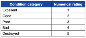
- Excellent—Less than 25 percent of the feature is disturbed. There is little to no evidence of disturbance from unauthorized activity resulting in any loss of information potential.
- Good—25–50 percent of the feature is disturbed. There is minor disturbance by unauthorized activity (e.g., moving of pot shards, user-created trails).
- Poor—51–75 percent of the feature is disturbed. There is moderate disturbance by unauthorized activity. Although not apparent to the untrained eye, some material may be missing from the site.
- Bad—76–99 percent of the feature is disturbed. There is clear evidence of major disturbance by unauthorized activity (e.g., pot hunting, graffiti).
- Destroyed—100 percent of the feature is disturbed, including subsurface damage or disturbance of the entire surface. The feature has so deteriorated from unauthorized activity that it is no longer eligible for national designation or no longer provides wilderness value (e.g., dismantled and removed, wildfire, flood).
Once the condition category has been assigned for each cultural site, note the associated numerical rating according to the following table 2.6.2.
Step 3: Retrieve Data from NRM. Local wilderness staff must review the information retrieved through NRM-WCM for accuracy and completeness. If discrepancies are found, corrections will have to be made through the appropriate staff with access to NRM-Heritage.
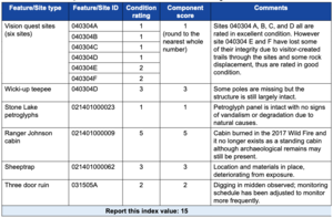
Step 4: Enter data in the WCMD. The NRM-WCM applications will automatically calculate the index value for this measure based on data retrieved from NRM-Heritage. NRM-WCM calculates the index value for this measure in two basic steps. First, a component score for each integral cultural feature is generated. For simple features that are composed of a single cultural site, the component score is the numerical rating assigned for that site. For features that cover multiple sites, the component score is the average of the numerical ratings for all individual sites that make up that integral feature. Second, NRM-WCM then sums the component scores for all integral cultural features to produce the final index value. Table 2.6.3 provides an example showing how to calculate the index value for this measure. In this table, the Feature/Site Type is a general narrative description that does not provide any specific location reference; the Feature/Site ID is preferably the Forest Service Site Number (to facilitate interaction between the heritage and wilderness programs), or may be the Smithsonian ID number, State Historic Protection Office ID number, or another form of identification.
Caveats and Cautions
Local units will first need to mark integral sites in NRM-Heritage and NRM-Buildings, and thereafter condition data for those sites can be retrieved from NRM-WCM.
Data Adequacy
Data adequacy is considered to be high. Features determined to be integral to wilderness character are likely those which have some level of existing documentation. Data quantity is likely to be complete and data quality is likely to be good—if the assessments are done by qualified, cultural resource program or facilities specialists. Data adequacy must be verified locally for each wilderness.
Frequency
Every 5 years, data on features integral to wilderness character are retrieved and the index value is calculated. The index value is then entered in the WCMD. Field data collection may span multiple years within the 5-year reporting interval.
Threshold for Change
The threshold for meaningful change is any change in the measure value for all integral cultural features. A decrease in the measure value beyond the threshold for meaningful change results in an improving trend in this measure.
6.3 Indicator: Deterioration or Loss of Other Integral Site-Specific Features of Value
This indicator focuses on the condition of other site-specific features determined to be integral to wilderness character. There is one measure for this indicator that is required if relevant to the individual wilderness.
6.3.1 Measure: Condition Index for Other Features
This measure is an index that aggregates the condition rating for each site-specific feature (or collection of similar site-specific features) determined to be integral to wilderness character. Local data are compiled and stored in local archives. The WCMD calculates the measure value. Table 2.6.4 describes key features for this measure.
Protocol
Step 1: Determine which other features are integral to wilderness character and feasible to monitor. This measure includes non-cultural features such as iconic geological, paleontological, and other features integral to wilderness character. Only those features determined to be integral to wilderness character should be included in this monitoring (i.e., those features that define the meaning and significance of the area). Detailed information about how to determine what features are integral to wilderness character can be found in section 6.1 in part 2. Where there is little or no information about other features of value within a wilderness, some inventory may be necessary before local managers determine whether any features are integral to wilderness character. Local units can also acquire information from the Automated Lands Program (ALP) to help identify significant special interest areas within a wilderness. For example, the EDW contains ALP information about botanical areas, geological areas, national natural landmarks, paleontological areas, research natural areas, and other areas.
In deciding which features to include in this measure, it is essential to consider monitoring feasibility. For integral features included in this measure, a qualified resource specialist will need to conduct an initial site condition assessment, establish a 5-year monitoring schedule, and regularly enter condition data into a locally maintained database. Consult local resource specialists or wilderness staff to evaluate the feasibility of establishing condition monitoring for integral features that are not currently being assessed. If a feature is considered integral to wilderness character but local units lack the resources to feasibly monitor it over time, do not include the feature in this measure. Such features may be added to this measure in the future if site condition monitoring becomes feasible; however, any modification of the list of integral other features should be considered carefully as changes in the measure value may affect the trend in this measure.
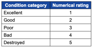
Step 2: Develop condition assessments and determine the condition of each integral feature. Once integral features have been identified for monitoring, work with local wilderness staff and relevant resource specialists to develop a meaningful condition assessment for each type of feature. It is recommended that units develop a five category rating system (e.g., excellent, good, fair, poor, or destroyed) for each type of feature. The qualitative definitions for each condition category are recommended to be similar to those used for cultural features if possible (see measure Condition Index for Integral Cultural Features, section 6.2.1 in part 2). For example, condition categories for paleontological features could be defined based on percentage of site integrity. However, some integral other features may require different condition categories to provide locally relevant information. An example might be for an iconic plant or tree species where the categories could be based on aerial coverage, sapling recruitment, or a combination of population metrics. Likewise, categories for a glacial feature could be based solely on aerial extent. While condition categories should focus on disturbance caused by human activity, they may include some disturbance where the causal factor is unclear. For example, the decline of an iconic plant species included under this measure may be related to natural or human-caused change, or some combination of the two. Local units must document the condition categories developed for all types of integral features.
Even though the qualitative category descriptions may vary depending on the type of feature, the scale of their associated numerical ratings should be the same as the scale used for cultural features (e.g., the numerical ratings should range from 1 [excellent condition] to 5 [destroyed or worst condition]). This consistent scaling is necessary to calculate the index value and apply the same threshold of change. Table 2.6.5 shows the recommended framework for developing condition categories and their associated numerical ratings.
Once a condition assessment has been developed for each type of integral feature included in this measure, qualified resource specialists must complete condition assessments for each feature every 5 years and store the data in a locally maintained database. For integral features that encompass multiple sites (e.g., numerous fossil sites that cumulatively are an integral feature of value), the individual sites may be assessed collectively or separately. Condition assessments for integral features may also be conducted over a span of multiple years within the 5-year reporting period for this measure. For example, condition assessments may be completed for a fraction of integral paleontological sites each year, with a full cycle of monitoring (all integral paleontological sites included in this measure) completed after 5 years. Record the condition category and associated numerical rating for all identified features or sites.
Step 3: Enter data in the WCMD. The final measure value is derived through an index combining all integral features' numerical ratings. While this index is described below for reference, users will not be responsible for calculating the measure value themselves; instead, users will enter the assigned numerical ratings for each integral site in the WCMD (for features that encompass multiple sites, users must enter the numerical ratings for all individual sites). The WCMD will then calculate the measure value automatically. The measure value is the index value.
In calculating the index value for this measure, there are two basic steps. First, generate a component score for each integral feature. For simple features that are composed of a single site, the component score is the numerical rating assigned for that site. For features that encompass multiple sites, the component score is the average of the numerical ratings for all individual sites that make up that integral feature. Second, sum the component scores for all integral features to produce the final index value. Table 2.6.6 provides an example showing how to calculate the index value for this measure.
Caveats and Cautions
None.
Data Adequacy
Data adequacy is considered to be medium to high. Data quantity is anticipated to be complete because features that are truly integral to wilderness character are likely ones that have received some level of study and staff attention. However, data quantity may vary depending on the number of features considered integral to wilderness character, especially if a local unit determines that an integral feature includes a collection of numerous sites. Data quality is more variable because it depends on having qualified resource specialists available to complete the assessments, and may range from good to moderate. Data adequacy must be verified locally for each wilderness.
Frequency
Every 5 years, site condition assessments are completed by a qualified resource specialist, and the assigned condition ratings for all integral sites are then entered in the WCMD. The measure value is automatically calculated by the WCMD based on the entered data. Field data collection may span multiple years within the 5-year reporting interval.
Threshold for Change
The threshold for meaningful change is any change in the measure value for all integral cultural features. A decrease in the measure value beyond the threshold for meaningful change results in an improving trend in this measure.


